| News Details |
The Upper Euphrates Basin, the Geographic Reality and Developmental Possibilities
2022-04-23
Prof. Dr. Kamal Saleh Gazgoz Al-Ani
Member of the Administrative Board of the Upper Euphrates Basin Development Center and Lecturer at the College of literature/ University of Anbar
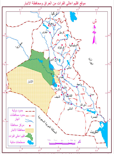
The Upper Euphrates Basin is represented in the western part of Iraq, which occupies for about 18% of Iraq's area and 56% of Anbar province. The basin has an area of about 76,975 km2 and is the main port of Iraq from the west with the Syrian Arab Republic and the Kingdom of Jordan as well as its border with Saudi Arabia, Nineveh province from the north, Salah al-Din and Baghdad provinces from the east, and Nikhaib from south region. Its height above sea level ranges from 1000-100 meters. The surface of the basin within the northern desert and the Jazeera consists of undulating land showing some hills as well as the highest height in Aneeza Mount on the Jordanian-Saudi-Iraqi border and up to 915 meters above sea level. A number of valleys are spread in the Upper Euphrates Basin such as (Okashat, Al-Manai’ee, Sawa’ab, Al-Walj, Jabab, Al-Gaser, Al-Fahimi, Al-Akhdar, Hajlan, Zaghdan, Banat Al-Hasan, Horan, Al-Marj, Al-Mehemdi) where the land flows with water during the rainy season and its waters is drained towards the Euphrates River, as an important source of the Euphrates River. These valleys and the disposal of all these valleys in the Euphrates River, as well as the presence of a number of valleys whose waters are internally drained and whose areas form arable soils. The existence of groundwater areas varying in quantity and geographical wells distribution, this reality encouraged Iraqi state to establish the most important project in this area, represented by the Desert Oases Project in 1973, most of which were sold in accordance with Law No. 32 in 1986 on the sale and leasing of State funds, and the State once again established desert oases along the highway from Traibeel to Ramadi, from which 10 of the 65 oasis areas were implemented. In 2001 oases were established on the Hit -Haditha- Al Qaim road, most of which suffers from neglect and the presence of a number of springs, like Ain Al-Asad, Al-Arnab, Jaroora, and Zazu.
The climate of this region is Arid- desert, characterized by a low rainfall (no more than 120 mm per year) except for some rainy years, and this is reflected in the lack of natural plant, although it is considered natural pastures for the breeding of livestock, especially sheep, goats and camels and in a limited zone. These types are annual and perennial plants, which exceed 400 species like (herb wormwood, Achillea, Thistles, Alhaji, Haloxylon, and some perennial shrubs as well as natural-use plants).
The Upper Euphrates Basin has a variety of mineral resources including phosphates, glass sand, limestone, iron and gypsum rocks, as well as oil and natural gas discoveries especially in Ak’Kaz region, which represent raw materials for a variety of industries as well as other types of minerals that make this area a distinct economic activity when used well.
Administratively, the Upper Euphrates Basin consists of six districts; Heet, Haditha, Ana, Rawa and Al-Qaim, as well as the Rutbah district, which occupies the first place in terms of area of about 45,360 km2 and constitutes 59% of the basin area. The population is estimated by the Ministry of Planning (415912) Population, 28% of Anbar province's population of 1418,598 for 2007. The urban population accounts for 63%, while the rural population accounts for 37%, with 154704 residents and 21.5% of the population in rural Anbar province. The population of the Upper Euphrates Basin countryside is spread along the Euphrates River and with rural stables of about 149 rural stables, of which 20 are located outside the Euphrates River.
The future trends of the Euphrates Basin through the development abilities are as follows:
1- The possibility of developing the Euphrates River and the Flood Plain through the optimal use of agricultural lands and preserving them from urban excesses in all of their forms as they are an important natural resource to provide food and reduce the import of agricultural crops from abroad.
2- Taking advantage of rainwater by building dams and reservoirs to benefit from it for human uses of all kinds, including agricultural use of plant and animal types, as well as its investment in tourism terms.
3- The possibility of developing the region by investing alternative and renewable energies like solar and wind for the purpose of producing and exploiting electricity to operate the projects on which it depends.
4- The possibility of developing fish wealth, especially in the lake of Haditha dam and using scientific methods to increase their species in addition to preventing illegal fishing such as the use of explosives, electricity and toxins.
5- The possibility of developing the region through an optimal investment of groundwater in the region and its exploitation for agricultural investment or the establishment of new desert oases in a scientific procedure to use this water through sprinkling or drip irrigation systems.
6- The possibility of developing the Upper Euphrates Basin tourism by investing the coastlines of the Euphrates River and the dam Lake as well as river landmasses from Al-Qaim to Heet in addition to desert tourism as well as the water springs found in the area, especially in the area of Kubaisa, as well as the exploitation of archaeological areas.
7- The possibility of establishing natural reserves to preserve wildlife, whether animal or plant, to be tourist areas in desert areas.
8- The possibility of developing the region by exploiting the existing and diverse mineral resources, particularly oil and natural gas within the Ak’Kaz region, in addition to developing and optimally exploiting the existing investment of minerals.
9- The possibility of developing the Upper Euphrates Basin administratively as a special administrative territory and issuing a government order to be at a governorate level through its natural and human possibilities.
10- The possibility of developing the basin educationally and scientifically in terms of the establishment of a university of the same name (Upper Euphrates University) as well as the establishment of a specialized institute concerns with the possibilities in the basin mentioned above.