| News Details |
One of the remote sensing techniques is the use of drones in the agricultural field
2022-08-15

Written by the researcher Ala’a Yaseen Muhammed
Master's degree- remote sensing– University of Baghdad
The global agricultural future carries with it a lot of technology, techniques and knowledge, ignorance of which will inevitably be a great danger, not only at the production level, which will coincide with conditions and challenges much greater than the current challenges.
Rather, the impact will also include the jobs, skills and experience required of an agricultural engineer. Those who do not possess these skills will not have a place in the midst of fierce competition for jobs in the future. As the world faces many challenges such as climate change and regional water challenges, it will be of paramount importance to use technologies such as Drones, which not only saves time and resources, but also gives experts timely and reliable data.
Therefore, it is necessary for future agricultural engineers to learn about this technology and acquire the necessary knowledge to choose the most appropriate Drone for their applications, clarify the methods of operating it correctly, and join training courses to train on how to operate it, and use it to collect information and how to extract and analyze that information.
The use of drones in modern agriculture
The beginnings of drones
· Since the late 1980s, remotely operated unmanned aerial vehicles such as remote-controlled helicopters have been operational in agriculture for applications such as control.
· But since 1990 remote control type has become a large-scale, independent drones are being introduced by (multicopter) for cultivation experimentally due to technical innovation from 2010 onwards.
· After the current COVID-19 crisis and the disruption of many commercial areas, industrial and agricultural businesses, especially aviation and air navigation, most pilots are currently turning to training in the techniques of using drones and their fields of military, scientific, technical and recreational uses..
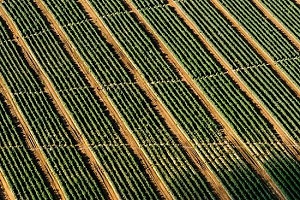
A picture from the drone of agricultural fields
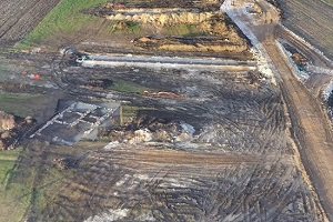
A picture from a drone of agricultural non-cultivated lands
The use of drones in agriculture:
Through the use of agricultural drones, engineers and researchers can see their fields from the sky, this smart technology can show many things related to agriculture such as:
§ Irrigation problems.
§ Soil differences.
§ Transmission and spread of pests and fungi among field crops.
· The multispectral images also show a near-infrared as well as a visual display of the spectrum.
· The data collected is used to evaluate crop growth and production.
· Make crops’ survey for the farms on an ongoing basis as needed.
· Drone technology can show the weekly, daily, or even hourly images of crop changes over time.
· It also shows expected trouble points, and after identifying these spots, the farmer can try to improve crop management and production.
One of the benefits of using drones in agriculture as well:
§ This technology is a great resource for analyzing the impacts of climate variability on crop production, water and soil resources, especially in marginal areas of the MENA region..
§ Drone technology has proven to be one of the best resources for agricultural experts, as its use leads to the understanding and analysis of various problems related to agriculture.
§ This technology has been used to spray pesticides over large areas using artificial intelligence drones.
The mechanism of using drones in agriculture
How to collect data on crops using drones:
§ There is a relationship between the reflection coefficient of the wavelength of agricultural crops and the growth condition, and in order to understand the crops’ growth status, it is necessary to use a chlorophyll counter (SPAD).
§ Data on crop growth is collected by installing a multi-wavelength camera that can be used for unmanned agricultural aerial vehicles. As the satellite imagery was used for similar applications..
§ But by using unmanned aerial vehicles with a small tipping point, more accurate information in this field is expected to be obtained more easily.
§ Drones (used for remote sensing) have great potential and reliable in agriculture, as well as being used to test crop health, track animals and conduct farm surveys..
§ It is also possible to combine high-resolution images captured by drones with satellite images in order to obtain better results.
§ Drones can take pictures of areas that sometimes satellites cannot cover due to many factors such as cloudy weather.
§ It is also possible to convert images into three-dimensional images covering 360 degrees through the use of special computer software; which opens the way for a virtual visit to an area.
§ This is in addition to its importance for construction planners in making the necessary measurements based on these images.
The role of the agricultural engineer in the use of drones in agriculture:
It is known that many custom agricultural machines have been manufactured, where the spraying of pesticides and fertilizers in particular is easy to program, because it is simple even in general aviation that flies in a certain range as the development of the drones has been in progress for a long time.
Remote sensing techniques, photogrammetry using aerial images captured by the use of unmanned aerial vehicles (Drones), which are specialized to remote sensing, and photogrammetry, the use of these unmanned aerial vehicles has become of great importance in modern agriculture..
In addition, the application of the use of drones in agriculture has become very effective and adopted by all agriculturally advanced countries without exception, and when mentioning agriculture and its data inputs, collecting and analyzing that data using satellites and drones, it will not be other than the agricultural engineer who is running those functions.
Advice for the agricultural engineer and research circles:
Whoever wishes to reserve a place for himself in the future amid rapid global changes, whether technological, technical or strategic, he must seek, train, and understand the near future and the evolving present in modern farming methods.
The limits of his knowledge should not stop at academic courses; one of the most important trends is the increasing use of drones in all fields, the most important of which is agriculture.
It is possible to browse the jobs of drone operators or pilots of drones and professionally collect data in different ways and use the cameras and sensors installed on those drones on most international recruitment websites. Especially in the areas of surveying and agriculture, you will find many of them with salaries worth the trouble of training and searching for that technology.
Our discussion ended today about the use of drones in modern agriculture, and because we are interested in providing everything that would benefit the agricultural engineer, especially in keeping pace with rapid developments, we also touched on explaining the concept of Organic Agriculture. We have dedicated an article to explain biodynamic agriculture and thee the difference between it and organic farming.
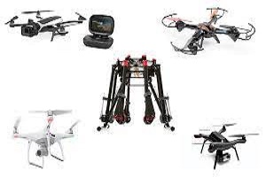
Best photos (9) Drones that are used in remote sensing and aerial photography for research and agricultural purposes