| News Details |
Satellite images detect a potential problem in some reservoirs of small dams
2023-04-16
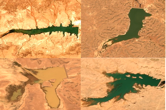
Satellite images obtained by the Planning and Database Department at the Upper Euphrates Basin Developing Centre at University of Anbar from European Space Agency satellites showed what could be considered an indication of a problem in the reservoirs of some small dams in the western region.
Dr. Haitham Abdul Mohsen Affan, satellite meteorologist, said that the images showed a decrease in the storage levels of dams (Shabija on Al-Huzaimi valley, one of the branches of Al-Ghadaf valley and the dam and um Al-Tarfat on Al-Abyad valley) rapidly and the loss of surface water storage significantly compared to the dams of the region such as Al-Rutba, Al-Rahalia and Al-Abyad Dam, which retained water for longer periods within the same period of time, which indicates the possibility of the presence of what is termed (sink hole) in the reservoir of these dams may the result of the construction of these dams on layers of soluble soil, which requires a comprehensive evaluation of their treatment and maintenance through injections of cement or other materials used in such cases.
With the increase in calls for the expansion of the construction of small dams and other water harvesting projects to benefit from rainwater and reduce the impact of supply shortages and climate changes, it is necessary to work in parallel to direct research and studies towards surveys of the types of soils in the region, their chemical composition, engineering and geological properties in the region, in a way that contributes to supporting the accuracy of the designs for these important projects.
To view satellite images of the Shabija Dam.... Click here
To view the satellite images of the um al-Tarfat dam .... Click here
To view satellite images of Rutba dam..... Click here
To view satellite images of Abyad Dam..... Click here
To view satellite images of Rahalia Dam...... Click here
#university_of_anbar
#Upper_Euphrates_Basin_Developing_Center