| News Details |
The depression of Khir El-Ain and the possibility of operating it
2023-06-02
Assistant Lecturer Sulaf Taha Dawood
Upper Euphrates Basin Developing Centre – University of Anbar
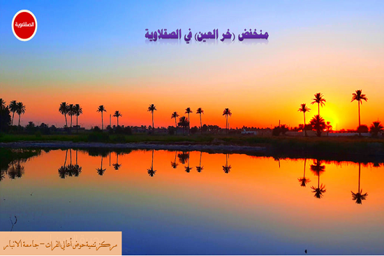
The depression (Khir El-Ain) is located near the regulator of new Saqlawiya, specifically within the Al-Buakash district, north of the centre of Al-Saqlawiya district, map (1), as it is 350 m away from it, bordered to the north by the Tigris arm channel, to the west by Al-Saqlawiya regulator and the Euphrates River, to the south by the centre of Al-Saqlawiya district, and from the east by Al-Garma district, the area of the depression is (32) dunums, divided by the highway line into two parts, while the northern section has an area of (13) dunums and the southern section has an area of (19) dunums.
The Khir El-Ain depression is one of the natural depressions that showed a prominent role during the Ottoman Caliphate, especially in the years (1871-1917) AD when the course of Saqlawiya was a river in which ships flowed, as it was a marina for ships coming from (Istanbul) and the Ottomans established a communications center on which a castle and shops were built, and this depression was a popular tourist resort teeming with fishermen, in addition to the fact that (Russians) used to spend their rest time in it during their working days in the Tharthar project, but there was no left From it today only the effects until its importance faded for several reasons, including.
· A massive flood generated by the Euphrates River destroyed the buildings that used to be built on it, leaving only traces.
· The implementation of the Tharthar project road led to the burial of the canal that connected it to the Saqlawiya stream.
· Implementation of the highway to divide the depression into two parts and then build an earthen dam in the city center until it is divided into three parts.
· Currently, it is used as a drainage in which harmful insects breed and is a source of unpleasant odors, especially in the summer.

Map (1) Depression of (Khir El-Ain) within the Saqlawiya district
Source: Based on Earth Google, map scale 1:20000.
With regard to the low (Khar Al-Ain) and the possibility of operating and suitability of its water for purposes, activities and events of tourism, sports and drinking, it is not suitable for these purposes at the present time, according to previous studies, field study and laboratory analyzes of its water and comparing the results with the classifications specified for each use.
By studying the reality of the situation of the study area, in which it was found that there are encouraging possibilities for tourism investment, for several considerations:
· The advantages of the location of the area within the sedimentary plain area are that it is a rural backdrop where green meadows breed.
· The importance of the geographical location suitable for tourism because it mediates the urban centers that depend on the banks of the Euphrates, which constitute the centers of great population gravity and thus supply the project with local tourists.
· Paved transport routes to the site and the proximity of the site to the capital Baghdad.
· The location is very suitable for water tourism, especially in summer.
· The possibility of establishing large nature reserves for different animals.
· The presence of the ancient Saqlawiya pathway and the control tower of the company (Marshall), which was opened in (1920) AD by the British.
In order to invest it properly in terms of exploiting and investing the available tourism potentials that work to develop the backward tourism reality of the region, as it was found that the region has large areas and archaeological areas close to urban centers, as well as it is far from the capital Baghdad (60 km), all these factors combined help achieve spatial development if the following are followed: -
1. Rebuilding what is on the ground in the depression (Khir El-Ain) and developing it completely includes all parts of the excavation and lining and isolating it from the drainage as in the pictures (1) and rehabilitating the roads and archaeological facilities represented by the control tower of the Marshall Company and the old Saqlawiya pathway as it is a heritage that must be preserved, and this needs exceptional efforts to implement it, because what has been mentioned above suffers from neglect in all respects and aspects.
2. Redevelopment of archaeological areas and investment for the purpose of the recreational aspect by planting dense trees in the form of forests surrounding these areas.
3. Proposing new tourism projects for the region in terms of establishing new various tourism activities upon redevelopment (Al-Khir depression) due to:
· The need to increase the aesthetic of the city to attract the largest number of tourists.
· To increase the efficiency of tourism projects in the region, which returns a great economic return.
· It provides large areas of empty land that can be invested in the expansion process to plant trees. and forests and fed with water by Khir El-Ain drip irrigation system.

Image (1) development proposal of (Khir El-Ain) depression