
Monitoring the spread of forest fires with satellites images
During the past few years, the world has actually begun to fall within the direct consequences of global warming, which is what many scientists have been calling for and warning about, the necessity of finding early solutions to address the causes of the emergence, expansion, and amplification of the effects accompanying and resulting from this negative climate condition, and what may follow from it. One of the phenomena that includes the world as a whole.
Forest fires are one of the most prominent consequences of global warming and are among the factors causing disturbance in most vegetation areas around the world, such as forests and grasslands. They represent a challenge for ecosystem management due to their ability to be both beneficial and harmful at the same time. Technology can play an important role in preventing, monitoring and responding to wildfires. Fire detection is a crucial stage in forest fire management, which aims to either fight or monitor fires.
Early detection of the outbreak of fire is considered essential, and this is what is happening so far through human surveillance and what is supposed to follow it by combating this fire in early periods after its outbreak to ensure that it does not spread and get out of control.
When any fire occurs in forests, it requires the application of certain formulas of treatments and studies to understand the possibilities that may occur later. Among these formulas and information requires:
1. Fire detection and mapping of burned areas
2. Real-time forecasting and monitoring of forest fires
3. Modeling and managing forest fire risks
4. Mapping areas at risk from fires
5. Monitor fire-prone areas
6. Mapping burn scars for recovery
7. Regrowth of vegetation after fire
8. Determine the best technologies and software to help achieve the above goals
Remote sensing techniques in studying forest fires
The use of fixed optical cameras for surveillance, or aerial surveys, is not considered sufficient for firefighting operations, so monitoring forest fires and their effects in large areas has become primarily dependent on remote sensing via satellites. Mapping burned areas and assessing the effects of forest fires is one of the most successful applications.
Satellite remote sensing provides a means of obtaining comprehensive and coordinated information about the impacts of wildfires over large areas at low cost. The burned area is mapped using a wide range of remote sensing sensors at different wavelengths. Later, this technology developed through the use of a range of wave frequencies within radar recordings to detect fires, starting from local to global ranges.
The best feature of satellite recordings is their repeated passage over the stricken area at specific time periods. This allows following the growth of the fire focus and the direction of its potential expansion, thus making it easy to predict areas of spread and possible treatments. Below is a figure showing the start of a fire and its spread during the first five hours.( Fig 1)
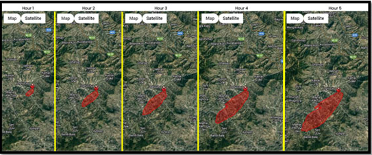
Fig 1 : The fire focus spread during the first five hours
Satellite recordings also provide us with the ability to determine the direction of the wind blowing and its intensity, as this has a direct impact on the movement of fires to other nearby areas due to the wind and its intensity. The stronger the winds, the greater the possibility of transmission, along with determining the direction of movement. The figure below shows the change in fire intensity due to the strength of wind gusts during the day.
.png)
Fig ( 2 ) The effect of wind on the spread of fire
Another feature of satellite recordings is the possibility of producing thermal maps of the fire hotspot, from which the actual size of the fire can be determined and the amount of damage to the areas adjacent to it can be predicted through the temperature gradient downward from the hotspot to the outside. These thermal maps are recorded with special thermal sensors mounted on satellites. The figure below shows the temperature gradient of the fire from the focus to the outside, giving the temperatures according to color.
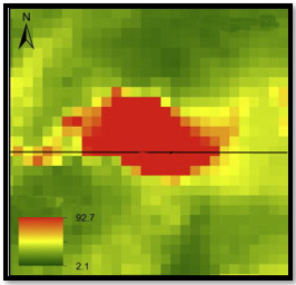
Fig ( 3 ) The red color is the hottest spot and it gradually descends to the green color, which is the adjacent safe areas.
It is clear from the above that satellite technology, its recordings, and its repetition can provide very important information about the emergence, spread, and movement of fire and smoke in forest areas, and thus facilitate taking the measures and treatments required to extinguish or even stop these fires within specific areas and prevent Its spread to neighboring areas.